| Main Page -> Maps (2) -> Baker - Africa |
|
|
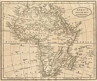
A higher resolution scan of the map. - 2277209 bytes
There is an amazing amount of detail in this map for a time when Europeans had so little knowledge of the internals of the continent. Many maps even decades later still left major portions of the continent empty. The 19th century would bring many European explorers into the continent that would be followed later by Christian missionaries and then colonization by the European powers. Much of the exploration of the early and mid 19th century centered around the many rivers of the continent. Some notable rivers on this map are:
| Nile | This map predates the "discovery" of the (true) source of the Nile by the Speke and Burton expedition of 1858 by just over half a century yet feels confident enough to actually label the source of the Nile in "Gondar" (Lake Tana near Gonder in modern Ethiopia (the source of the Blue Nile)). The White Nile and the connection to Lake Victoria are conspicuously absent. |
| Niger | It is also of note that the Niger river empties into Lake Bournou in Bournou
(modern Bornu?) rather than the Atlantic Ocean (at the Gulf of Guinea). I suspect that
the map refers to Lake Chad and mistakes the Niger river for the Hadejia. The
actual exit of the Niger appears to be the "Formosa" river on
this map. The Niger was seen by Mungo Park several years earlier and his (erroneous) reports may have contributed to the problems of this map. |
| Senegal | I am unable to determine what Lake Maberia is, as nothing like that seems to exist even near that location. My best guess would be the Boucle du Baoulé National Park in Western Mali as it is actually on the Senegal river (as shown on the map). |
| Zaire | Now known as the Congo, this gets little attention considering that it is the tenth longest in the world and second longest in Africa. It will be over 70 years before Henry Morton Stanley descends the Congo. |
Another notable discrepancy is the single lake on the eastern side of the continent. On the map it is labeled as "Great Like Marava or Zambre". While it resembles both Lake Malawi and Lake Tanganyika it is unclear which one it is, if not a combination of the two. Europeans would not reach either lake for several decades after this map was created.
The map is labeled as "Engraved by B. Baker Islington". This time matches with Benjamin Baker (1766 - 1841) an engraver who worked in England as a principal engraver for the Ordinance Survey. A map of Europe from the same source has been included as well.